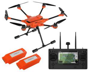

Yuneec - H520Professional drone with 2 batteries and ST16S remote control. Camera sold separately.
Technische ficheHandleidingCommercial Aerial Solution
The H520 system utilizes Yuneec’s proven six-rotor platform and incorporates enterprise-grade cameras and mission planning software for high-end commercial use.
Built For Industrial Applications
Yuneec UAV are built for inspection, law enforcement, security, construction, surveying, and mapping applications in addition to offering cinematic or broadcast-ready imaging payload systems.
Reliable, Stable And Precise
Yuneec Commercial UAV are designed with the inspection industry in mind with six-rotor systems that allow for stable, precise flight, medium focal length lenses that allow the UAV to fly at greater distance from an object and data storage to SD card in 4K/2K/HD video or 12Mp still images, and transmit to ST16S Ground Station in 720p video link resolution.
Hot-Swap Payload Options
Yuneec camera payloads are interchangeable and hot-swap capable, offering time-saving convenience for the commercial operator by not requiring a power-down restart of the UAV system. This also allows consistency of data-storage, rather than using multiple storage devices and locations. Whether it’s thermal imaging, long focal length, or wide focal-length data capture, memory cards may be swapped from device to device.
ST16S All-In-One Controller
The ST16S Ground Station is an all-inclusive transmitter and receiver that gives you full control over the H520 during flight, allowing users to capture photos and video with great ease. With a large 7-inch integrated screen, the Android-based ST16S controller displays real-time footage of your flight, eliminating the need for an external device. You can also use the ST16S as a mission planner. Plan your flight using the touch screen, and execute your mission with just a single press of a button.
DataPilot
Yuneec DataPilot™ software system enables users to efficiently and consistently create orthomaps, 3D scans, crop data imagery, in the field or on the desktop for repeatable, recallable aerial flight paths, without requiring expensive third party software.
Key Features
- Six-rotor (Hex) safety, stability and reliability
- High wind-resistant airframe
- Interchangeable payloads/sensors
- Up to 28 minute flight time based on payload weight (2x included with each H520 drone)
- 2D / 3D mapping capability
- 360º continuous rotation camera gimbal
- Waypoint, Survey Mode, Point to Fly (inc. offline maps)
- Ultra-Low operating noise
- High satellite coverage (GPS, GLONASS, GALILEO)
- Service packages available
- Retractable landing gear
- ST16S ground station with 7” HD Touch display
- DataPilot™ mission control software system
- HDMI® output for HD display to Command/Control
- Yuneec SDK application development